


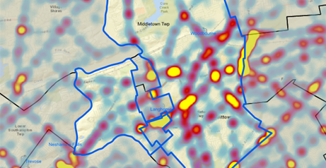
Crash analysis identifying hot spots
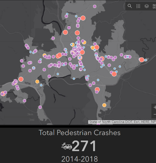
Interactive pedestrian crash dashboard for the City of Asheville
SERVICES OVERVIEW
Building Asset Management Systems & Telling a Story with Maps
Using Geographic Information Systems (GIS), TPD has collaborated with municipalities to develop a means to identify and track their municipal assets and historical records. TPD provides the following services to municipalities to inventory and track their assets.
- Create user searchable databases
- Link asset information with GPS coordinates
- Create Report Quality Mapping to better display information to the public and clients
- Improve/show concept roadway alignments within GIS
- Build asset management databases using ArcCollector, a tool from ESRI
TPD also has expertise in developing mapping products that tell stories, engage the public and establish the foundation of plans and studies. Staff of TPD are proficient in ESRI ArcGIS Pro and ArcOnline to produce these products and to execute geoprocessing tools. These products include:
- ESRI StoryMaps: TPD has produced several such StoryMaps to narrate the story of a plan or project and act as a community engagement tool
- ESRI interactive data dashboards that allow users to manipulate data based on maps and other fields in the data
- ESRI Web Mapping Applications: user-friendly online maps that allow clients and the public to easily interact with maps
- Traditional print or pdf maps that are attractive and easy to understand
AT A GLANCE
GIS Database, Bensalem Township
For Bensalem Township, TPD geographically linked all of the Township’s Traffic Signal Permit Plans and specific information for each signal. The system graphically shows and links to recent traffic counts, proposed land developments, roadway projects.
- Other useful information throughout the Township was also linked to allow us to suit their specific needs, including:
- Mapping for local grant application
- Tables and maps created for Townships Street Lighting Retrofit Pilot Program
Future Uses:
- Track Township wide accident information obtained from PennDOT
- Import all street light locations, specifications, parts, and maintenance records from the townships web-based lighting monitoring system
- Create Pedestrian Asset Data Base to plan pedestrian routes throughout the township